

You are here
Mapping Changes Resource Set
Mapping Changes Resource Set
The resource set includes additional sources to accompany the Primary Source Set and Lesson Ideas to help extend lessons and further student understanding. Primary Source Analysis Worksheets are available on the Elementary Primary Source Sets main page.

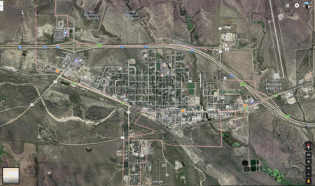
Harrison Avenue in Leadville, 2015 (Photograph)
Downtown Leadville, Colorado looking down Harrison Ave. August 18, 2015. (Photo by Andy Cross/The Denver Post)t)
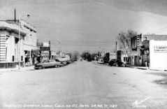
Business district, Limon, Colo. on U.S. Hwys. 24, 40, 71, 287 (Photograph)
[between 1940 and 1950]
View along Main Street, business district, Limon, Lincoln County, Colorado, includes the brick First National Bank, "Shermon's Clothing, Red Goose Shoes" "Houtz Drugs, Walgreen Agency" "Dodge, Plymouth" "Texaco" "Firestone, Vulcan Tires" and "T. L. Baskett & Co., Farms, Ranches, Land."
Financial information on schools and districts throughout Colorado. Learn more about financial transparency.
Colorado Dept. of Education
201 East Colfax Ave.
Denver, CO 80203
Phone: 303-866-6600
Contact CDE
CDE Hours
Mon to Fri, 8 a.m. to 5 p.m.
See also Licensing Hours
UPDATED
March 24, 2025
Copyright © 1999-2025 Colorado Department of Education.
All rights reserved.
Title IX.
Accessibility.
Disclaimer.
Privacy.

Connect With Us


